


: Distinct operations with qualitative results- Full communiqué- Video")


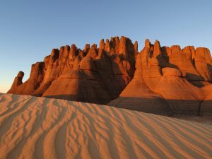
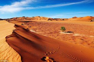
The Algerian Desert is located in north-central Africa. It covers more than four-fifths of the Algerian territory. It starts from the Saharan Atlas, more or less as a stony desert and the farther inland you get the more of a sand dune desert it becomes.
This area contains lush oasis towns and villages scattered throughout the region like precious gems in the sand. These settlements are often inhabited by families who have lived there for generations, many with fascinating tales to tell of the extensive history and fascinating culture of the people and of the area. Even the barren landscape between oasis towns has an undeniable beauty which thousands of visitors have come to appreciate.
This area is a subject of great archaeological interest and was put up on the “World Heritage List” by UNESCO in 1982.
The magnificent limestone plateau in Saharan Algeria known as the M’zab Valley is considered to be of such historic significance that it has been designated as a UNESCO World Heritage Site.
The towns in the M’zab valley include Ghardaïa, Melika At Mlishet, El Guerara, Bounoura At Bunur, Bérianne, Beni Isguen At Isjen and El-Ateuf Tajnint.
The area is known for extreme aridity and extreme heat, as daytime temperatures are commonly between 46 °C (113 °F) and 51 °C (122 °F) during the hottest period of the year in most of the desert.
Cities and towns such as Ouargla, Touggourt, Beni Abbes, Adrar, In Salah are among the hottest places on Earth during the height of summer. Annual average rainfall is well below 100 mm (3,93 in) in the northernmost part but the center and the southern part receive much less than 50 mm (1,96 in) and are therefore hyper-arid and among the driest places on Earth.


Algeria+Wiki.


 day 2022")

: Distinct operations with qualitative results- Full communiqué- Video")


